
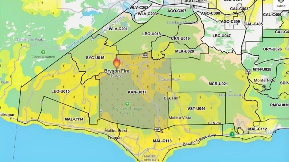
Malibu, California: The Bryson Fire spread rapidly in the Malibu area of Los Angeles County on October 15, prompting evacuation orders and warnings for residents in several designated zones. According to the latest available incident update from CAL FIRE, the wildfire had expanded to approximately 200 acres by 9:35 p.m. local time.
The fire began near Encinal Canyon Road in the Santa Monica Mountains area. It was initially reported at around 35 acres before growing to approximately 80 acres and then expanding further as fire activity increased.
The incident is being handled by the Los Angeles County Fire Department. CAL FIRE’s incident page listed the cause as under investigation. The agency’s published update did not provide confirmed figures for destroyed structures, damaged buildings or injuries.
Evacuation Orders and Warnings
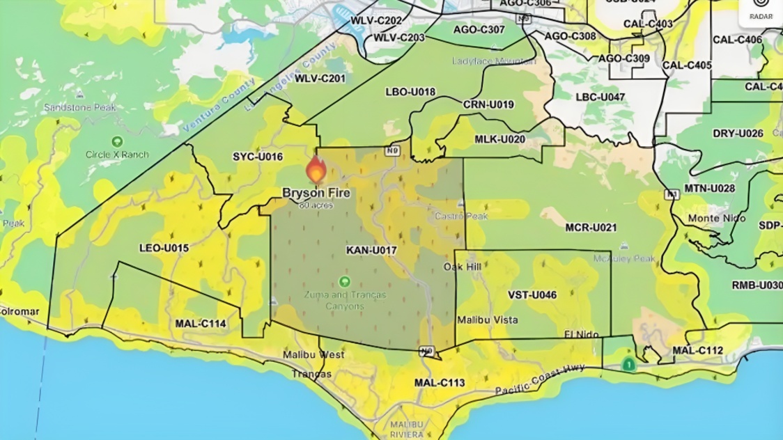
Los Angeles County authorities issued evacuation orders for specific areas threatened by the fire. According to the available CAL FIRE incident information, the order zones included KAN-U017 and SYC-U016-A.
Evacuation warnings were issued for additional areas, including LEO-U015, MAL-C113, MAL-C114, CRN-U019, LBO-U018, MCR-U021-A, MLK-U020, SYC-U016-B, SYC-U016-C, SYC-U016-D, VST-U046 and WLV-C201.
An evacuation order means residents in the affected area face an immediate threat and must leave as directed by authorities. An evacuation warning indicates a potential threat to life or property. Residents who need additional time to leave, including people requiring assistance and households with pets or livestock, are advised to prepare early and follow local instructions.
These designations apply to specific zones. Residents should not rely on general descriptions of the fire’s location alone to determine whether they need to evacuate. Official maps and emergency notifications provide the most reliable information about individual addresses and zone boundaries.
Shelters Available for Evacuees
Authorities listed Agoura High School, located at 28545 West Driver Avenue in Agoura Hills, as an evacuation shelter for residents affected by the fire.
The Agoura Animal Care Center, at 29525 Agoura Boulevard in Agoura Hills, was listed as an animal shelter. Residents leaving their homes should follow official instructions about shelter availability, access and any changes to evacuation arrangements.
Emergency officials generally advise people to prepare essential medicines, identification documents, mobile phones, chargers and other necessary supplies when time allows. People who require assistance with transportation or medical equipment should make arrangements as early as possible.
Residents should not delay leaving an area under an evacuation order to collect belongings. If authorities direct them to evacuate immediately, personal safety should take priority.
Strong Winds Increase Wildfire Risk
The fire developed during a period of elevated wildfire danger across Southern California. Los Angeles County had warned residents about strong Santa Ana winds, low humidity and dry conditions that could allow fires to spread quickly.
The National Weather Service issued a Red Flag Warning for parts of Los Angeles County covering October 15 and extending into October 16. Forecast wind gusts in mountain areas were expected to reach approximately 50 to 70 miles per hour.
Strong winds can carry burning embers beyond the main fire perimeter, allowing new fires to start ahead of the advancing flames. Dry vegetation can also ignite quickly, making it more difficult for firefighters to contain a fast-moving wildfire.
County officials urged residents to identify evacuation routes, prepare essential supplies, keep emergency alerts enabled and avoid activities that could create sparks near dry vegetation. Residents were also advised to keep roads clear so emergency crews could reach threatened areas.
Firefighting Efforts and Nearby Communities
As the fire expanded, emergency services monitored conditions around Malibu and the Santa Monica Mountains. The fire’s location near Encinal Canyon Road brought concern for nearby communities and facilities in the surrounding area.
News reports said the fire threatened a Los Angeles County juvenile detention and rehabilitation facility, prompting evacuation measures there. Officials also issued orders and warnings for a wider area as the situation developed.
The available incident update recorded the fire at 200 acres, but it did not establish a final containment figure. Fire size, containment status, evacuation boundaries and the number of threatened structures can change as crews continue their work.
Residents should therefore use the latest updates from Los Angeles County emergency services and the Los Angeles County Fire Department rather than relying on earlier estimates or unverified social media posts.
How Residents Can Check the Evacuation Map
Residents can check their evacuation zones through the official Genasys Protect platform linked by Los Angeles County. The county’s emergency information page also provides updates on evacuation orders, warnings and available shelters.
The official links are particularly important because an evacuation order may apply to one zone while nearby areas remain under warning or advisory status. Conditions can change quickly as wind direction and fire behaviour change.
People should follow instructions issued by local authorities and emergency responders. Anyone facing an immediate threat should call 911. Residents should avoid entering closed areas or returning to evacuated neighbourhoods until officials say it is safe.
What Happens Next?
The next stage of the response will depend on fire behaviour, weather conditions and firefighting progress. Authorities will continue assessing the affected area, updating evacuation information and investigating the cause of the fire.
The latest available incident update recorded the Bryson Fire at approximately 200 acres on the night of October 15. Evacuation orders and warnings were listed for designated zones, and shelters were identified for affected residents and animals.
The situation remains time-sensitive, so the status of evacuation orders, warnings, shelters and containment should be checked again before publication. Residents in affected areas should rely on official emergency alerts and obey evacuation instructions without delay.