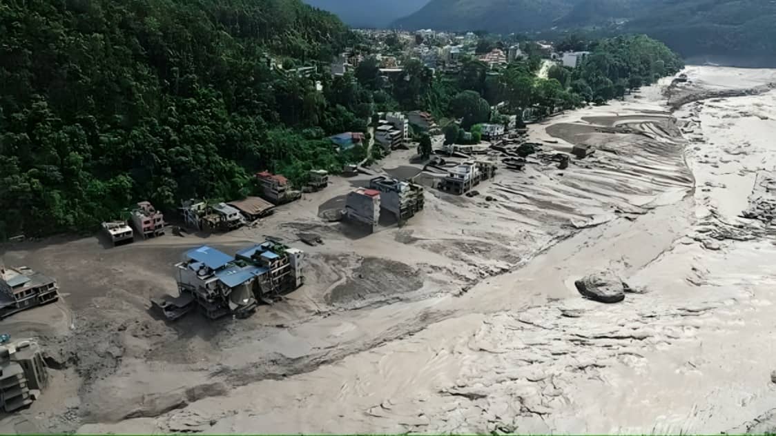
Nepal is facing one of its most devastating recent natural disasters after a sudden flash flood swept through communities near the Nepal China border. The disaster is believed to have been triggered by the collapse of part of a Himalayan glacier, which caused a massive ice rock avalanche and a sudden surge of water, mud and debris.
According to preliminary scientific assessments, the lower section of a glacier collapsed at a high altitude before crashing onto the valley below. The falling ice and rocks gathered additional debris as they moved downward and eventually struck the Lhende Khola river system.
The avalanche is believed to have temporarily blocked the river. When the natural blockage was breached, a huge volume of water and debris rushed downstream at great speed. The resulting flood moved through the Bhote Koshi and Trishuli river systems, destroying settlements and infrastructure along the way.
One of the most alarming aspects of the disaster was the speed at which the river level increased. Experts said water levels in the affected river system rose by as much as 9 metres within just 30 minutes. Such a rapid rise gave residents and travellers very little time to escape.
The flood struck mountainous communities including Timure and other settlements in Rasuwa district before moving further downstream. Roads, bridges, homes, vehicles and power infrastructure were damaged or completely swept away by the force of the water and debris.
The death toll has continued to rise as rescue teams recover bodies from affected areas. Nepalese authorities have reported 162 deaths, while many people remain missing. The missing include security personnel, local residents and foreign tourists travelling through the Himalayan region.
The disaster has also affected international travellers because the region is an important route for tourists and pilgrims. A significant number of foreign nationals have been reported missing, including visitors from India and several other countries.
The sudden nature of the disaster has made rescue operations extremely difficult. Many roads have been destroyed, while thick layers of mud and debris have covered homes and other buildings. In some areas, rescue workers have been forced to rely on helicopters because ground access has been severely restricted.
Nepalese security forces and emergency response teams have been deployed across the affected areas. Helicopters are being used to search for survivors, transport injured people and deliver essential supplies to communities cut off by the flooding.
The disaster initially raised questions about whether an earthquake had triggered the glacier collapse. Early reports suggested that a magnitude 4.4 seismic event may have destabilised the mountain environment. However, subsequent analysis by the United States Geological Survey indicated that the seismic signal was generated by the glacial collapse and debris flow itself rather than by a conventional earthquake.
Satellite imagery has played an important role in understanding what happened. Images analysed by scientists showed a section of the glacier collapsing from an elevation of roughly 5,200 metres and falling approximately 1,200 metres to the valley floor.
The falling ice and rock then created an enormous debris flow. When the material entered the river system, it disrupted the normal flow of water and created the conditions for the devastating flash flood.
Experts have described the event as an ice rock avalanche rather than a conventional rain related flood. This distinction is important because the disaster occurred despite the absence of prolonged heavy rainfall in the immediate area.
The International Centre for Integrated Mountain Development has highlighted the speed and scale of the flood. Its observations indicated that the river system experienced an extraordinary rise in water levels, demonstrating how quickly a glacier related event can transform into a major downstream disaster.
The affected rivers eventually connect with larger waterways that flow toward India. The Trishuli River becomes part of the Narayani river system, which enters India and is known as the Gandak River. Because of this connection, developments in the Nepalese Himalayan region are also being closely monitored downstream.
The disaster has raised renewed concerns about the vulnerability of Himalayan communities to sudden glacier related hazards. The Himalayan region contains thousands of glaciers and numerous communities are located downstream of rivers originating in high mountain areas.
When glaciers collapse or large quantities of ice and rock suddenly enter river systems, the resulting flood can travel considerable distances. The steep terrain of the Himalayas can further increase the speed and destructive power of such flows.
Climate scientists and mountain experts have repeatedly warned that changes in the Himalayan environment are increasing risks associated with glaciers, landslides and other natural hazards. Rising temperatures can affect glacier stability and contribute to changes in high altitude landscapes.
However, experts have cautioned that establishing a direct link between a particular disaster and climate change requires detailed scientific investigation. The immediate trigger in this case appears to have been the collapse of a glacier and the resulting ice rock avalanche.
The disaster has also highlighted the importance of early warning systems. A flood that raises river levels by several metres within half an hour can be extremely difficult to manage unless communities have access to reliable monitoring and rapid communication.
Early warning systems that monitor glaciers, rivers and potential landslide zones could provide valuable time for downstream communities to evacuate. However, establishing such systems in remote mountainous terrain is technically challenging.
The latest disaster is particularly concerning because the affected region has experienced serious flood events before. Experts have warned that the combination of unstable mountain slopes, changing glaciers and densely populated river valleys can create repeated risks.
Rescue workers are currently facing several challenges. Thick mud has covered roads and buildings, bridges have been destroyed and some areas remain difficult to access. Continuing instability in mountain slopes also creates additional risks for emergency personnel.
Authorities are using helicopters, drones and ground teams to search for survivors. Rescue operations are expected to continue as officials attempt to locate missing people and recover victims.
The number of missing people remains uncertain because communications have been disrupted and many affected communities are difficult to reach. Authorities have also been receiving new information from families and foreign governments about people who may have been travelling in the region.
The presence of foreign tourists and pilgrims has added an international dimension to the rescue operation. Several countries are monitoring the situation and coordinating with Nepalese authorities regarding their citizens.
India has also responded to the disaster by providing humanitarian assistance and disaster relief material to Nepal.
The disaster has caused significant economic damage as well. Roads connecting important towns and border areas have been damaged, while bridges and power infrastructure have been swept away. The destruction could affect transportation, tourism and local trade for an extended period.
The affected border region is strategically important because it connects Nepal with Tibet. The flood also caused damage around the Gyirong border area on the Chinese side, where mud and debris affected infrastructure.
The destruction of roads and bridges means that restoring transport links will be a major part of the recovery process. Heavy machinery and engineering teams will be required to clear debris and rebuild damaged structures.
The incident has also generated discussion about the safety of infrastructure constructed in vulnerable Himalayan valleys. Roads, hydropower projects, bridges and settlements are often located close to rivers because of the difficult terrain.
When an extreme flood occurs, these structures can become highly exposed to fast moving water and debris. The latest disaster has therefore raised questions about how future infrastructure projects can be designed to withstand sudden mountain hazards.
Scientists are continuing to analyse satellite images and geological evidence to determine the exact sequence of events. Further studies could help establish how much ice and rock collapsed, how long the river was blocked and how the subsequent flood developed.
Understanding the process could help authorities improve hazard mapping and warning systems in other Himalayan regions.
The disaster also highlights the importance of cooperation between countries sharing Himalayan river systems. Nepal, China and India are connected through rivers that originate in the mountains and flow across national borders.
Information sharing about glacier movement, river levels and potential landslides can help downstream communities prepare for sudden changes. Cross border cooperation could become increasingly important as extreme mountain events become a greater concern.
For Nepal, however, the immediate priority remains the rescue of missing people and assistance to survivors. Thousands of people have been affected directly or indirectly by the flooding.
Families are continuing to search for information about relatives who disappeared when the flood swept through settlements and travel routes.
The authorities have warned that the death toll could rise because rescue teams have not yet reached all affected locations. Additional bodies may be discovered as mud and debris are cleared from roads and buildings.
The tragedy has also demonstrated how quickly a natural event in a remote high altitude area can develop into a large scale humanitarian emergency.
Within a short period, a glacier collapse transformed into an ice rock avalanche, temporarily disrupted a river, and generated a massive flood surge downstream. The river level increased dramatically, while communities had little time to react.
The reported 9 metre rise within 30 minutes illustrates the extraordinary speed of the event. For people living or travelling close to the river, even a few minutes can make the difference between reaching safety and being caught in the flood.
Experts are therefore expected to focus not only on the immediate cause but also on how future risks can be identified earlier.
The Nepal disaster is likely to become an important case study for understanding glacier related hazards in the Himalayas. Detailed satellite imagery, geological surveys and river data could provide valuable information for improving disaster preparedness across the region.
For now, Nepal continues to deal with the aftermath of the catastrophe. Rescue teams are searching for survivors, authorities are assessing damage and families are waiting for information about missing relatives.
The confirmed death toll has reached 162, while hundreds of people remain unaccounted for. The final number of casualties could increase as search operations reach more remote areas.
The evidence available so far indicates that the disaster was triggered by a glacier collapse and subsequent ice rock avalanche, rather than a conventional rainfall driven flood. The avalanche blocked the river before releasing a powerful surge of water, mud and debris downstream.
The speed of the flood, combined with the steep Himalayan terrain, created extremely destructive conditions.
As Nepal begins its recovery, the disaster is likely to prompt renewed attention to glacier monitoring, early warning systems, emergency preparedness and climate risks in the Himalayan region.
The tragedy serves as a reminder that natural hazards in high mountain areas can quickly cross geographical boundaries and affect communities, infrastructure and travellers far downstream.